.jpg)
AirWorks has significantly expanded its technical capabilities over the past couple of years.
As infrastructure programs have grown more complex, with larger corridors, tighter timelines, and more demanding data standards, AI is now the best way to meet demand. Our geospatial AI platform has evolved to support the speed and accuracy that AEC requires. What began as advanced 2D extraction from raw field data has expanded to include LiDAR capabilities, 3D deliverables, optimized layer detection, and enterprise-grade integrations. For AEC teams, that evolution means enchanced project site intelligence and dramatically faster project timelines. It also means engineering teams can move into design and field validation with better information earlier in the project lifecycle.
These capabilities support a wide range of AEC workflows, including ALTA surveys, feasibility studies, transportation planning, golf course development, stadium and event site planning, existing conditions reports, and as-built documentation.
LiDAR Processing and 3D Deliverables
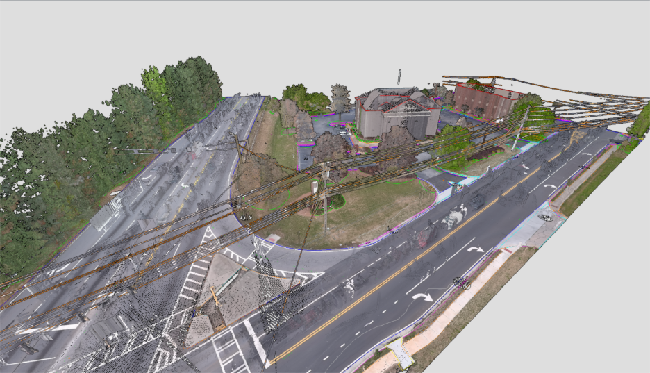
AirWorks is best know for fast 2D planimetrics, but over the last year, we have made great strides in our 3D AI capabilities. As a data agnostic platform, AirWorks can now ingest LiDAR point clouds in addition to 2D imagery inputs. This enables 3D deliverables where vertical data, clearance violation detection, and elevation modeling are needed. In AEC environments, these 3D outputs are particularly useful for topographic modeling, drainage planning, and hydrographic analysis, where understanding how water moves across terrain is critical.
For corridor design, site development, utility coordination, and existing conditions modeling, this added dimensional capability provides an incredible amount of project site clarity before teams ever step foot into the field. The objective remains the same: accurate, actionable linework derived from raw field data, now expanded into a new dimension. For teams less familiar with working directly in LiDAR point clouds, AirWorks translates that data into structured vectors and breaklines that can be used immediately in engineering environments.
Introducing Customer Solutions Engineers: Your AirWorks Engineering Team Member
We know our customers can oftentimes be resource-strapped. That is why we have created the Customer Solutions Engineer team, a dedicated technical resource for every AirWorks client. Our customer solutions team is made up of civil engineering, CAD, GIS, architecture, and geospatial experts whose role is to support the technical execution of projects and guide customers through AirWorks AI and platform best practices.
We will act as your end-to-end project delivery partner with thorough project support, custom layer standards, and deliverables in your CAD and block templates.
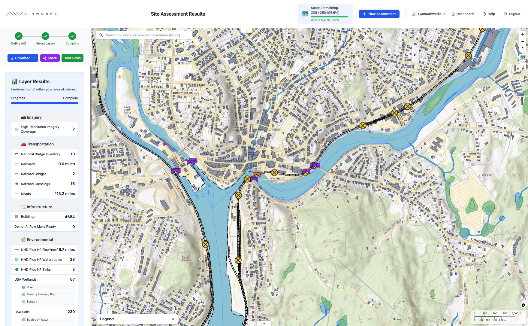
More 2D Layers & Deduplication
At the same time, our 2D capabilities have also advanced substantially. AirWorks now detects and delivers more layers, including precise locations of pedestals, valves, handholds, tree trunks, culverts, ADA ramps, and more. This greatly expands the depth of infrastructure, terrain, and asset information available in our processed project data. For AEC teams working through early design, permitting, and coordination phases, more complete existing conditions intelligence reduces downstream revisions.
AirWorks now also performs vector deduplication to remove overlapping geometry that can cause visualization issues when CAD models move from model space to paper space. This results in cleaner deliverables that behave more predictably inside drafting workflows. Combined with continued improvements in model accuracy and QA, the output is more consistent and more usable inside engineering workflows.
Faster Turnaround, Better Quality
In parallel with technical development, our operational processes have matured. We’re always listening to customer feedback and have greatly sped up our turnaround times in response. On average, AirWorks is now delivering projects 1-2 days ahead of estimated delivery dates. As a result, we’ll be updating our standard turnaround times at the end of March.
.png)
On-Demand Imagery & Tasking Partners for your Project, Budget, and Timeline
AirWorks remains fully data-agnostic across LiDAR and aerial imagery datasets. We have a long-standing partnership and integration with Nearmap to support feasibility and quick ALTA surveys powered by on-demand aerial imagery. We have also expanded our data partner network to include Eagleview imagery, drone collections with FlyGuys and Zeitview, and mobile LiDAR through NCTech. Whether you need maximum precision or quick on-demand data, AirWorks can facilitate getting you what you need for your project, budget, and timeline.
For AEC firms managing varied project types, this flexibility allows teams to select the most cost-effective and best-fitting field data without compromising output quality. This flexibility allows teams to avoid unnecessary capture costs by selecting data that matches the scope and precision requirements of the project. And our high-accuracy processing standard remains constant, regardless of the input source.
Formats & Templates that Engineering Teams Love
As capabilities have expanded, integration maturity has followed. AirWorks exports processed project data in formats AEC teams use daily, including GDB, shapefile, DXF, DWG, GDB, and DGN workflows. Deliverables integrate directly into environments such as ArcGIS, AutoCAD, and Bentley platforms.
We have also developed structured CAD and block templates to align outputs more closely with client standards and internal drafting conventions, allowing teams to ingest AirWorks deliverables with minimal formatting or rework. If you don’t want to introduce a new system but rather accelerate operations in the one your team already works in, AirWorks can support you.
AEC firms today are balancing larger backlogs, tighter schedules, and limited technical staff. Delivering more projects without sacrificing engineering rigor requires better leverage of field data. AirWorks’ expanded capabilities are designed to support that reality, providing accurate, actionable geospatial data faster, in formats that integrate cleanly into existing design workflows.
For firms seeking to improve throughput, accelerate early-stage design, or enhance existing-conditions intelligence, AirWorks has evolved into the leading option.
.png)