.png)
For years, collecting high-quality field data has required a mix of hardware, software, manual workflows, and time-consuming data processing. At AirWorks, our mission is to fix that.
That's why we're excited to introduce a fully integrated 3D field intelligence solution combining industry-leading XGRIDS sensors with the AirWorks platform. We can now capture rich 3D field data faster than ever and have it seamlessly processed into actionable digital twins for our customers.
It’s the complete workflow, from capture to insight in one integrated solution.
A Seamless Connection Between Data Hardware and Software
With XGRIDS sensors, collecting reality capture data is as simple as walking a site, mounting the sensor on a vehicle, or attaching it to a drone. Once the data is collected, AirWorks takes care of the rest.
The result? High-quality digital twins delivered back to your team quickly, ready for planning, engineering, design, and analysis.
No disconnected workflows. No complicated processing. No unnecessary delays.
One Solution from the Field to the Office
AirWorks now provides everything you need to deploy reality capture across your organization:
- XGRIDS sensor sales at exclusive AirWorks customer pricing
- Hardware setup and onboarding
- Team training
- Ongoing technical support
- Integrated AirWorks processing
- Access to the AirWorks Automate platform
Within Automate, teams can:
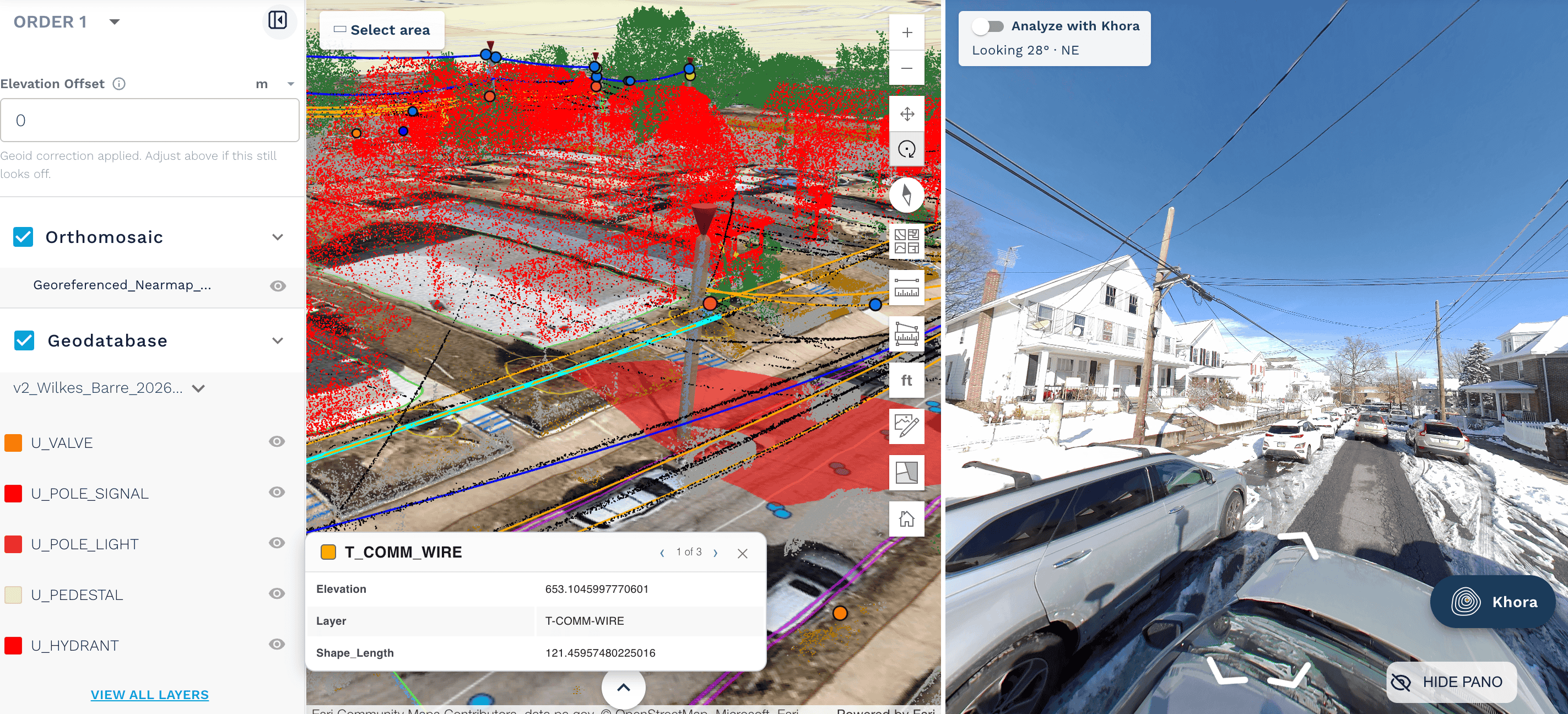
- Visualize projects in rich 3D
- Explore and navigate digital twins remotely
- Take accurate measurements
- Perform virtual walkouts
- Collaborate without returning to the field
Your office gains immediate access to field conditions without waiting for additional site visits.
Actionable Intelligence, Not Just Point Clouds
Capturing reality is only the beginning. AirWorks transforms collected data into engineering-ready intelligence that helps teams identify:
- Clearance violations
- Vegetation encroachment
- Permit-ready make-ready analysis
- Existing infrastructure conditions
- Assets required for planning and design
Whether supporting new network builds, utility upgrades, or ongoing maintenance programs, AirWorks delivers the insights needed to make faster, more informed decisions.
New Subscription Packages Make Scaling Easy
Alongside this launch, AirWorks is introducing new subscription packages designed to make reality capture easier to adopt across organizations.
Instead of worrying about the size of every project, customers can choose subscription options that enable continuous scanning and processing as part of their normal operations.
The new plans provide predictable pricing, greater flexibility, and the freedom to capture more projects without constantly evaluating individual project costs. These new packages will be particularly useful for regular scanning of smaller sites, including more maintenance projects.
The goal is simple: empower field teams to collect more data while making it easier for engineering teams to put that data to work.
Built for Every Type of Field Operation
The flexibility of the XGRIDS platform allows organizations to collect data however the job demands.
Sensors can be:
- Carried by field crews
- Mounted on vehicles
- Attached to drones
- Used across telecom, utilities, transportation, and infrastructure projects
No matter how data is collected, AirWorks provides the same seamless processing experience and delivers consistent, high-quality digital twins.
Get Started with a Low-Risk Pilot
Organizations interested in modernizing field data collection can begin with a low-risk pilot engagement.
Experience how integrated hardware, automated processing, and AI-powered analysis can reduce field revisits, accelerate engineering workflows, and support both new construction and maintenance projects faster than ever before.
If you’re ready to simplify field capture and turn reality into actionable intelligence, AirWorks is ready to help your team get started.
Learn more about the XGRIDS sensors here.
%20(411%20x%20258%20px)%20(1).png)

.png)
.png)

