%20(411%20x%20258%20px)%20(1).png)
Partner Spotlight is a new series looking at the partners our customers rely on every day: where each one fits in the geospatial workflow, how AirWorks connects with it, and what that means for teams using both.
We're starting with Esri. Esri's ArcGIS is central to how many engineering, utility, and infrastructure organizations manage geospatial information, and it's where much of the data AirWorks produces ultimately lives.
Where Esri fits
For many organizations, ArcGIS is where project data becomes part of a larger system of record. GIS teams use it to manage assets and network inventory: poles, conductors, right-of-way, and underground utilities. Field teams read and update that same data through ArcGIS field apps. And GIS teams typically own the standards that keep it usable across the organization, including schemas, domains, symbology, coordinate systems, and attribution requirements.
The challenge is that the work required to create new project data does not always happen inside that environment. Field data may be collected for a new project, then processed and drafted through a combination of specialized tools and manual workflows before it ever reaches GIS. By the time it gets there, a GIS analyst may still need to reconcile file formats, coordinate systems, attributes, and schemas before the information can actually be used. AirWorks is designed to make that handoff much simpler.
From raw field data to the GIS environment
AirWorks is a geospatial AI company. Our models extract accurate, attributed linework and features from aerial imagery, LiDAR, and other field data, and that automation is what makes it practical to deliver every project to the customer's own GIS standards rather than a generic structure that has to be translated later.
In practice, that means:
- Deliverables in file geodatabase format, with features organized to match your existing feature classes
- Attributes populated to your schema, including coded-value domains
- Data positioned in your coordinate system, with no re-projection needed before loading
Instead of handing a GIS team a collection of disconnected project files to assemble, AirWorks can deliver a vetted, attributed dataset that is ready to move into the customer's existing workflow. For teams already invested in ArcGIS, the goal is straightforward: make newly extracted project information easier to put to work.
.png)
Beyond the GIS team
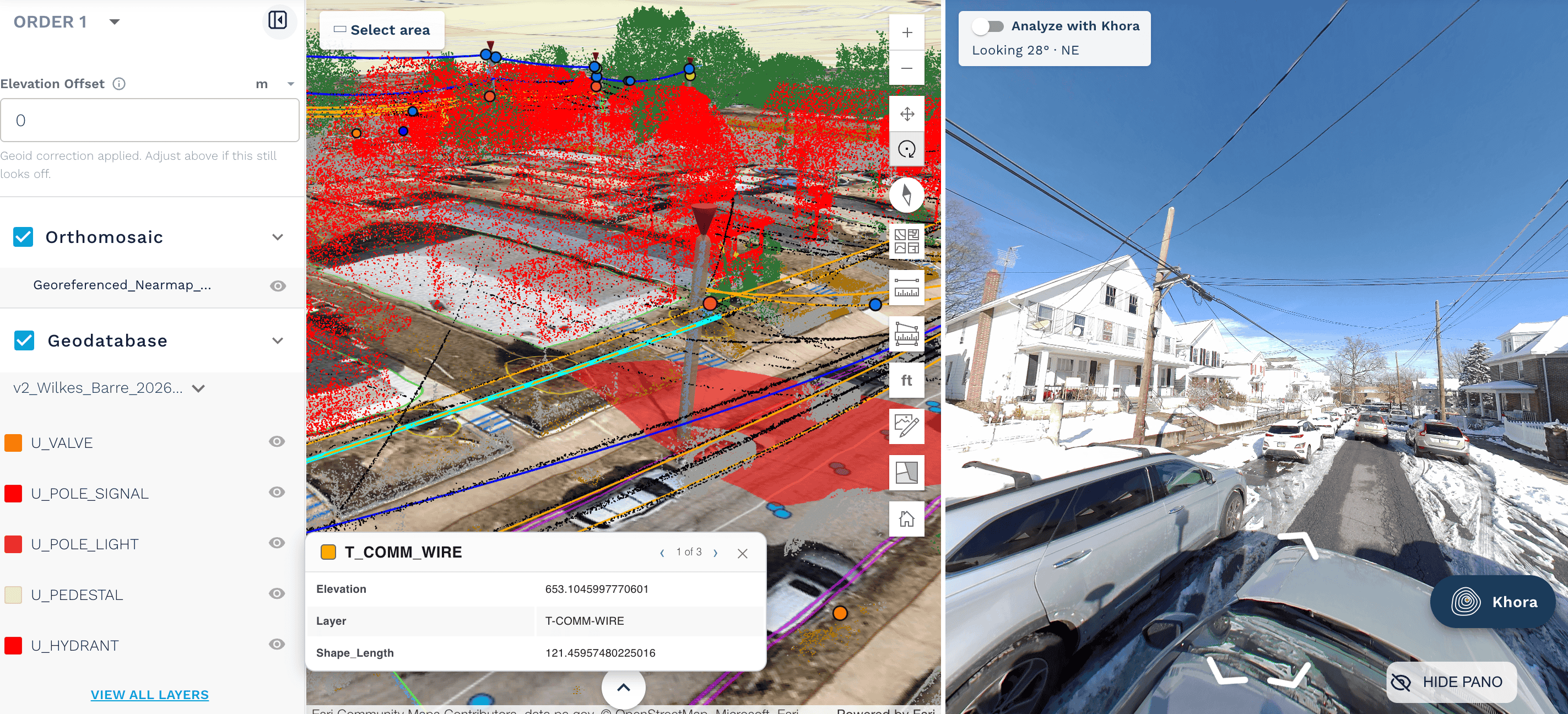
AirWorks Project Viewer is built on Esri technology. It gives project managers, engineers, field supervisors, and clients a browser-based way to inspect vectors, imagery, classified point clouds, panoramas, and attributes together. Your GIS environment stays the system where standards and assets are managed; Project Viewer extends access to everyone else who needs to see the data. (More on that in our recent post, The Impact of Proper Data Consolidation.)
The workflow
- Order a project in AirWorks Automate.
- AirWorks' geospatial AI extracts features from your field data, and our team vets and delivers them to your schema, attribution, and coordinate system.
- Stakeholders review the results in Project Viewer.
- Your GIS team loads the deliverable into ArcGIS, with no reformatting required.
It's a direct path from field data to information your engineering, GIS, and project teams can use right away. It is another way to extend the value of an existing GIS investment without requiring every stakeholder to become a GIS power user
How it looks in practice
For an organization already using Esri, the workflow can be relatively simple.
A project is ordered in AirWorks Automate. Raw field data is processed into accurate, actionable geospatial deliverables that reflect the customer's requirements. The resulting project information is available through the AirWorks Project Viewer for broader project access and can be delivered in formats and schemas designed to fit the customer's established GIS workflow. The result is a more direct path from field data to information that engineering, GIS, and project teams can use in a highly practical, highly effective manner.
That connection is what we want to explore throughout this Partner Spotlight series: how those technologies and solutions fit together in the real operations that our customers rely on every day to complete the amazing work that they do.
See it in action
Book a demo to see Project Viewer and how AirWorks deliverables fit into your existing GIS environment. Be sure to stay tuned for our next partner spotlight!

.png)
.png)
.png)

